In recognition of Indigenous Peoples Day, I want to share some research for my next map drawing. The topic is to match modern roadways to original trails from Oak Grove Mission in modern-day Bloomington to the ricing and hunting grounds around White Bear Lake. My focus is on the 1830s, a time before all the Dakota and Ojibwe land was ceded and the US Dakota War of 1862, an attempt at land acknowledgement.
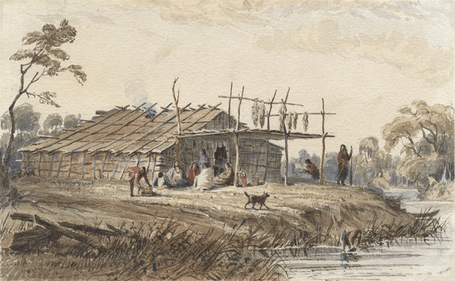
In my art maps, I typically showcase the historic and notable architecture of a neighborhood. To recognize the history of Hyeáta Othuŋwe, the Dakota village located on the east side of Bde Maka Ska (fka Lake Calhoun), I chose to feature the Dakota long house. The MPR news story about the Prairie Island Indian Community creating a bark lodge was inspirational: https://www.mprnews.org/story/2022/08/03/prairie-island-celebrates-the-first-bark-lodge-in-150-years
In 1829, Maȟpíya Wičhášta (Cloud Man) established Hyeáta Othuŋwe with the intent to try farming in the European method with sponsorship from Lawrence Taliaferro, Indian Agent at Fort Snelling. The village grew from two families in 1829 to 73 families (221 people) by 1838. In 1839, Maȟpíya Wičhášta moved his people to the Minnesota River Valley near Bloomington, largely because of increasing hostilities with the Ojibwe people.
Not a lot of records exist that document how the Dakota people lived at that time, especially not created by the Dakota people, but two non-Indigenous sources helped helped me develop a medallion for Hyeáta Othuŋwe: missionary Samuel Pond’s book Dakota Life in the Upper Midwest and US Army Officer Seth Eastman who was an artist assigned at Fort Snelling, see https://rchs.com/publishing/catalog/seth-eastman-a-portfolio-of-north-american-indians/ .