Peabody’s Landing

Park Point – August 17, 2023

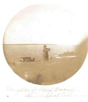
August in Park Point is green and full of raspberries and jewel weed. A completely different world from the snow-dune blanketed peninsula of my last visit in April. This time I followed the map from my most recent drawing of Park Point to the location called Peabody’s Landing to confirm what I suspected from the research completed at my kitchen table earlier. The narrow sidewalk that runs from the trail to the shore of the Superior Harbor is a remnant of Peabody’s Landing, named for the ferry service run by Charlotte and John Harry Peabody, who lived on the Point.

In 1853, George Stuntz, deputy U.S. surveyor, established a trading post, warehouse, dock and transfer company at the Landing. He ferried people and goods between Wisconsin and the Point and was granted exclusive rights of usage by the Territorial Legislature for a period of fifteen years. Stuntz traded with the Anishinaabe people for whom the Point was still a seasonal home and sacred site of their burial grounds. The 1854 Treaty of La Point established the Fond du Lac reservation and while the treaty was to maintain the Anishinaabe’s rights to hunt and fish freely outside the reservation, treaties were broken.

As early as the 1850s, vacationers made the short trip across the harbor to Park Point. By 1900s, the Peabody’s were ferrying the wealthy citizens of Duluth and Superior across the harbor to summer cabins built on federally-owned land. Superior’s Mayor Charles O’Hehir kept a cabin there from 1900-1927, and that Pine Knot Cabin was the last cabin on the site, razed in 2010.

References:

George Bonga and Fort Saint Louis

The first European settlement along the Duluth Superior Harbor was Fort Saint Louis, a trading post of the North West Company. The fort was located at the present day intersection of 2nd and Winter Streets in Superior, WI, near the depot from which Thirsty Pagan Brewing operates. The North West Company was first organized in 1779 in Montreal and dominated the North American fur trade west of the Rocky Mountains in the early 1880s. Their agent Jean-Baptiste Perrault oversaw construction of the fort in 1793 and John Sayer managed it during its peak years. By 1805, the fort employed 109 people and its stockaded walls contained 2 one-gun blockhouses, two 40′ long houses and 60′ warehouse and shed. After the War of 1812, control of the area shifted from British Canada to the United States. The Fort of Saint Louis ceased business in 1916 at which time the American Trading Company established Fond Du Lac Fort up river on the Duluth side.

Images of Fort Saint Louis were difficult to find, however the Minnesota Historical Society maintains another North West Company trading post at Ginebig-Ziibi (Snake River) https://www.mnhs.org/furpost built near the same time and also managed by Sayer. This museum and David Geister’s drawing below served as inspiration for the depiction of Fort Saint Louis on my Park Point drawing.

The Snake River Fur Post as it appeared during John Sayer’s tenure as partner in the early nineteenth century. Drawn by David Geister, ca. 2000. (https://www.mnopedia.org/multimedia/drawing-snake-river-fur-post)

George Bonga captured my imagination as I read about the history of Fort Saint Louis. He was born in 1802 to Pierre Bonga (a Black fur trader working from Fort Saint Louis) and Ogibwayquay (an Ojibwe woman). George Bonga worked in northern Minnesota as a fur trader and translator, speaking English, French, and Ojibwe. He went to school in Montreal. He returned to the Duluth area and frequently guided white travelers and traders through the region. He worked as an advocate for the Ojibwe in their dealings with trading companies and the United States government. His full story is worth the read here https://www.mnopedia.org/person/bonga-george-ca-1802-1874.

George Bonga, ca. 1870s (Photo Credit https://www.mnopedia.org/person/bonga-george-ca-1802-1874)

Frank Little and the Allouez Ore Docks

When you walk along the Park Point trail, at a certain point you see enormous hulking dark ore docks across the Superior Bay. The ore docks are no longer in use as of 1970, but they still have a profound presence in Superior and Allouez bays.

Darla the Dog in her element at Park Point, 4/16/2019

Also known as the Burlington Northern Ore Docks, these docks were the largest in the world and consisted of three structures of concrete and steel. The were used from 1890 to 1970. The longest dock was 2244 feet long, 80 feet high, and contained 374 individual pockets which can hold 100,000 long tons of ore or 7 average trains of 205 cars each. Over one billion tons of ore were shipped through these docks, the largest year’s shipment being 32.3 million tons in 1953. (https://www.hmdb.org/m.asp?m=147249)

Working conditions were hard on the docks. In 1913, workers walked off the job after two ore punchers were crushed to death. Ore punchers climbed on top of the train cars hauling ore and broke up frozen ore with poles so the ore could be loaded on to ships. The men who died in 1913 were killed when the trains began to move without any notice to the workers.

Frank Little (1879-1917) represented the Industrial Workers of the World. He was involved in organizing lumberjacks, metal miners, migrant farm workers, and oil field workers into industrial unions, often as part of free speech campaigns. He arrived in Duluth in August to support the strike of the ore-dock workers against the Great Northern Railway over dangerous working conditions. In the course of the strike he was kidnapped and held at gunpoint outside of the city, until he was rescued by union supporters.

Frank Little’s story is compelling but short. I recommend this video of Jane Little Botkin giving a talk to the Montana Historical Society about her research and her book Frank Little and the IWW.

Chief Joseph Osaugie

As I was researching the history of the Duluth Superior Harbor for my drawing of Park Point and learning details of the tragedy of broken treaties that I should have known more about lived in Minnesota my entire life, I was heartened to run across this article from the Duluth Reader: Chief Osaugie Gets His Wisconsin Point Home Back.

Chief Joseph Osaugie (Ozzagii) 1802-1876 – Photo credit Geni.com

Chief Joseph Osaugie led the Fond Du Lac band of Ojibwe. He signed the second Treaty of La Pointe in 1854, which ceded most Ojibwe land on the northern and western shores of Lake Superior to the U.S. government. It also established the Grand Portage and Fond du Lac reservations. In exchange, the Ojibwe were to receive annual payments and a guarantee that they could continue to hunt and fish throughout this territory. The treaty appeared to have benefits to the Ojibwe people, whose livelihood was impacted by a decline of the fur trade. Many Ojibwe owed money to white or mixed-race traders and could no longer make enough from the fur trade alone to pay off these debts. Signing a new treaty appeared to provide additional income. (www.mnopedia.org Treaty of La Pointe)

The four Ojibwe Ceded Territories – Photo Credit: Courtesy of Great Lakes Indian Fish and Wildlife Commission

Chief Joseph was laid to rest in a cemetery on Wisconsin Point in 1876. Osaugie’s descendants were forced out of Wisconsin Point starting in 1915, when U.S. Steel wanted to build ore docks. Tribal members fought their case in court, unsuccessfully. From 1918 to 1919, their burial ground was dug up and relocated to St. Francis Cemetery in Superior in what was essentially a mass grave, 198 graves in 29 plots. The graves were poorly maintained and bones ended up washing into the Nemadji River. (Duluth Reader: Chief Osaugie Gets His Wisconsin Point Home Back. )

In August 2022 the City of Superior signed over deeds to the Fond Du Lac band for both pieces of land: the site of the burial ground on Wisconsin Point, and nearly an acre and the St. Francis cemetery, the site of the mass grave. (https://www.mprnews.org/story/2022/08/19/fond-du-lac-band-celebrates-return-of-sacred-sites)

The band of 4,200 members believes many more bodies remain buried on Wisconsin Point, as only those with marked graves were removed. It hopes to restore more land, to connect what it owns on the end of the point with the cemetery. In 2017 it reclaimed about 12 acres of surplus land from the U.S. Army Corps of Engineers. It wants to preserve and protect what is there, and find a way to educate those who come upon the site. (https://www.startribune.com/for-area-anishinaabe-a-piece-of-home-is-returned/600215975/)

Photo of a Daughter of Chief Osaugie – Photo credit to Descendents of Chief Osaugie Facebook group

The Old Standby

Minnesota Point Lighthouse – Photo credit to Minnesota Historical Society

A little more than half way along the Park Point, you pass the ruins of the first lighthouse in the Duluth Superior area. The map below is from my drawing Park Point, you can see the lighthouse location near the bend of the peninsula.

The red brick tower is a husk of what was the Minnesota Point Lighthouse, affectionately called “the Old Standby”. When the canal at Sault Ste Marie opened in 1855, Congress appropriated funds for its construction in anticipation of the logging and mining boom to come. The lighthouse served from 1858 to 1885. A replacement light was built on the northwest side of the Superior Entry in 1878, but the Old Standby functioned through 1885 as the kinks of the more modern light were worked out.

Samuel Stuart Palmer was the second lighthouse keeper of the Old Standby, from 1861 to 1871. He turned 66 the year he moved in with his second wife Roxanna .

His obituary read: Mr. Palmer was a native of Jefferson county New York. He came to the head of the lakes Superior in 1856 and for many years was keeper of the Minnesota point lighthouse. He leaves a widow, a large family of grown-up sons, of whom Jothan, Vose, Loren and Roswell reside in Duluth, and many grandchildren to mourn his loss. His funeral on the 3rd inst. at Nemadji cemetery Superior, was attended by many from Duluth and Superior, the Reverend Dr. Rice officiating. Thus one after another of our old settlers pass away. (From Superior Times 06 April 1878.)

Samuel S. Palmer (photo credit to Lighthousefriends.com)